UPDATES: See more recent map of proposed wind facility/transmission infrastructure locations based on a Wisconsin Public Service Commission filing made by Pattern in September 2023 and another map of this infrastructure superimposed on important bird resources previously indentified by the Wisconsin Department of Resources.
Additionally, see sample of an easement agreement document with language that the developer can use to acquire land access for 34. 5 kV collection lines (explained below), 345 kV grid tie lines and new substations that would be created.
- – – – – –
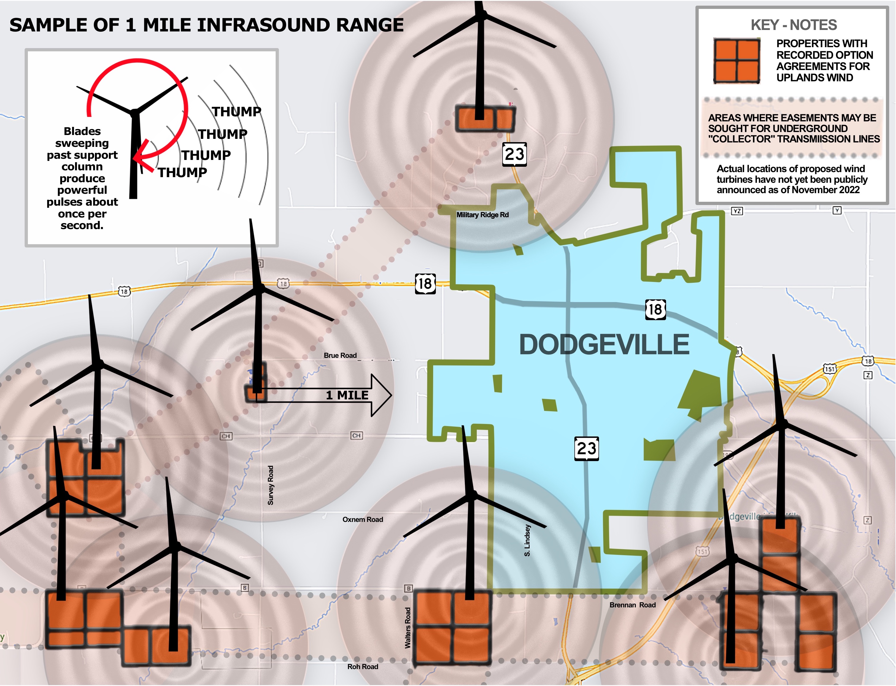
The below maps show land parcels under contract for potential wind power plant development as of November, 2022.
Select landowners in Iowa, Grant and Lafayette Counties have an unprecedented opportunity to work together and prevent some or many industrial scale wind turbines from being developed. More explanation follows below
Additionally, Town and Village officials in these jurisdictions have been presented the opportunity to request two meetings with Pattern Energy, the developer of the 600 MW Uplands Wind proposal. The first meeting is designated to provide exact, preferred locations of wind turbines and associated equipment in the municipality’s jurisdiction and the second to make suggestions that Pattern can consider and affect before their application is submitted to the Public Service Commission of Wisconsin. This information is essential for a municipality to be able to “work with” the developer as encouraged by the Public Service Commission of Wisconsin.
CLICK MAP TO VIEW LEASED LAND PARCELS NEAR YOU
CLICK MAP TO VIEW PROPOSED THREE COUNTY UTILITY DISTRICT
CLICK MAP TO VIEW SAMPLE INFRASOUND IMPACT AREA
 |  |  |
The information in this article was researched by five individuals whose lands, livelihoods, health and economic welfares are threatened by the proposed development of more than 250 square miles of very large-scale wind power plant development in Iowa, Grant, and Lafayette Counties, Wisconsin. The goal is to help potentially impacted landowners, residents and citizens at large become more aware of the enormous scale of the Uplands and Badger Hollow power plant proposals and steps that can help prevent or reduce negative impacts. As electric customers, we pay for all added power plants. Our research finds that these very costly plants pose unacceptable heath risks, are not compatible with existing land values and uses and would be much less effective at reducing CO2 emissions compared to using the billions, instead, to incentivize home and business based energy improvements.
WITHHOLDING CONNECTOR LINE EASEMENTS
The blue-green colored rectangles in the map indicate parcels of land in county records that landowners have signed over for possible uses by Pattern Energy, the under-regulated, “merchant” utility that wishes to build the Uplands Wind power plant. Similarly, the pink-colored rectangles indicate parcels in county records that owners have signed over for possible uses by Invenergy LLC, the under-regulated, “merchant” utility that wishes to build the Badger-Hollow wind power plant.
Ostensively, these marked land parcels can be used for several purposes including installation of wind turbines, access roads, right of ways, under or above ground high voltage “connection” lines, project substations and high profile transmission lines connecting the power plant to large substations. As can be seen in the below, to-scale, illustration, modern wind turbines are much larger than any turbines installed in Wisconsin, to date. The turbine models under consideration by the privately owned, non-public utility developers have not been specified but are expected to range to as large as 6.4 MW with heights of ~650 feet.

Each of the approximately 160 wind turbines in the two, proposed power plants must be connected to expansive, web-like networks made up of several dozen of high voltage power lines (34,500 volts or 34.5 kV). The heavy cables, or “Collection Lines” can transport considerably more power than the existing distribution lines in the area. Collection lines are either buried under ground or mounted on poles on the surface.
As illustrated below, wind power plants require a large number of Collection Lines that converge at Project Substations. The power from these Substations is collected and interjected into the area grid.

By zooming in to the contracted land parcels on the high resolution map of the Uplands/BadgerHollow projects, one can see that many of the blue-green, rectangular shaped land parcels are bunched together, as illustrated below. Because landowners have permitted collection line RIGHT OF WAY in the lease options they signed, the private company can add collection lines without additional land contracting.

However in many locations on the map, contracted parcels, stand alone, separated from the larger bunches creating gaps. As of November 2022, county records suggest that parcels in many “gap” areas have not yet been contracted by Pattern or Invenergy for power plant-related purposes. This condition is crucial for landowners to understand because those concerned about the lack of modern protections for public health and unwarranted negative impacts on property values can work together. They can refuse to sign RIGHT OF WAY easements and discourage the developer from adding connection lines needed to build stranded turbines, potentially, within 1250′ of occupied residencies.

Potential gaps in right of way for the Uplands Wind project are portrayed on the high resolution parcel map as blue-green tinted areas. Potential gaps in right of way for the Badger Hollow Wind project are portrayed on the high resolution parcel map as pink tinted areas.

CONTACTING INTERESTED NEIGHBORS
If you would like a neighboring volunteer to contact you to discuss ways to use the above information to engage your neighbors or your Town/Village officials, please email info@no-uplands.com . Please include the street address of your potentially affected property in your email so we can get you in touch with a volunteer who lives near you.